

Yosemite National Park, California (High Sierras) 9 Day Hike
 I’ve just spent the last nine days in Yosemite National Park (High Sierras, California) with three other photographers and one non photographer hiking between 7500 and 10500 feet.
Although the region is renown for being temperamental when it comes to weather, our group was lucky to only enjoy ideal conditions with a light breeze. The wind was beneficial, not only for cooling whilst climbing steep trails, but also for blowing away the “flying teeth” and mosquitoes which were prevalent during the trip.
“Flying teeth” are small nat-like insects which are barely visible until they bite! I soon discovered that any bare skin left uncovered or not covered with DEET was quickly found by persistent mosquitoes. Usually I shy away from using DEET, especially after noting that the chemical has a propensity to melt plastic. But, after a few days of being eaten alive, I succumbed to the fact that DEET although not the best moisturizer for your skin, is a necessary evil in some instances.
BASIC GEOLOGY
If you have formal training in geology, or a basic understanding of geological processes, Yosemite National Park is an open book to some impressive geological forces in action.
 Very briefly, the geology comprises granitic batholiths that have been exposed and eroded by glaciers since the last glacial epoch. The batholiths formed as a by-process of earlier subduction and orogenic processes (mountain building). Although the major period of glaciation has since ceased, much of the region above 9000 feet is still being eroded by the annual deposition of snow and the movement of ephemeral ice. The evidence indication glaciation can be observed throughout much of the park and includes: glacial moraines, melt-water streams, glacial cirque lakes, hanging valleys and glacial arêtes.
Standing upon an exposed batholith (granite rock dome), it’s readily apparent that the rocks have been eroded by a greater force. Pegmatites (mineral inclusions that have formed during earlier periods of melt activity) within the granite have been sliced in half and the overall rock is very smooth with glacial striations. Glacial striations are caused by the erosive ability of rocks carried in the basal layer of an ice sheet. As the ice moves across the base rock, the underlying rock is striated by the harder rocks carried in the ice; the direction of the striations providing an indication of the direction of ice flow.
BASIC FLORA & FAUNA
Below the tree line are several species of indigenous pine 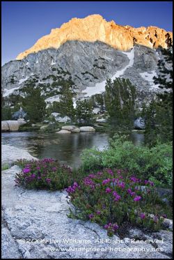 including the famed California Redwood which grows in ecological niches. In addition to these tall trees is an understorey of grasses profusely populated by dozens of alpine flowers. The alpine flora, although somewhat smaller in statute to their lowland cousins due to increased cold and more exposure to environmental elements, extends well into the alpine zone and many colourful species were observed dotted along the margins of glacial tarns, and paralleling spalding granitic outcrops scoured by previous glacial events. As difficult as it is to ignore this coloured floral spectacle, the area is also home to a vast number of animals including: the black bear, marmot, several squirrel species, lizards, snakes, and many species of birds.
WORKING AT ALTITUDE & ALTITUDE SICKNESS
One aspect of hiking above 8000 feet is altitude sickness. I personally thought I was fine, until I realized that I had a constant headache, slight insomnia, irritability, and difficulty in doing some concentrated tasks such as basic math and tying a reef knot! I found the irritability as a surprise; I thought I was fine until I was told to “pull my head in”. I only really realized it was altitude induced when I descended to around 7000 feet and began to actually feel like a different person from what I had been at altitude.
 The biggest hassle when hiking above 7000 feet is the inability to breath. Normal moderate hiking at sea level, when done at altitude, is the equivalent of running up a hill at sea level. As such, panting is quite common especially when climbing steep trail sections or “getting up a pace”. Carrying heavy photographic equipment only exasperates the problem.
The cause of altitude sickness is the atmosphere at 10,000 feet is thinner and comprises less than the usual 21% oxygen found at sea level. For the most part the effect of altitude sickness was only a minor problem and the condition decreased as you descended below 8000 feet.
PHOTOGRAPHY
As I was walking and carrying everything on this trip, I had to make several compromises to what I was going to photograph. Although my main interest is wildlife, I decided on this trip to bypass the urge to carry a 300 f2.8 or f4 lens and to concentrate on landscape work. I was more than happy with my decision until I found a colony of ground squirrels that had made their home on a glacial meadow. I was then cursing myself for not dragging a longer lens with me as the 24-105 f2.8 was just not long enough to capture the action of these wonderfully cute a furry critters.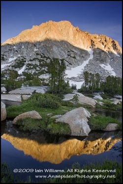 Photographically the area is beautiful, and not to return with a decent photograph is exceptionally difficult.
THE ACTUAL WALK
Tuolumne Meadows to Camp Vogelsang
I began the hike with three other people at Tuolumne Meadows which is accessible by road. We spent the first night at a camp near the car park to hopefully adjust to the altitude (in hindsight we should have spent longer than one night as this did little to allow for altitude acclimatization).
During the drive to the stepping off point we were all very concerned that the hike would have to be cancelled as the atmosphere was thick with wood smoke from several forest fires that were raging some miles away. The air of rancid with smoke and visibility was very poor. The group was delighted the following morning when wind conditions had altered somewhat to blow the smoke in the other direction!
We set out on the hike after a light breakfast (if there is such an animal in USA) and final checking of equipment which included removing every possible piece of food from Rebecca’s car, and either trashing it or placing it within the confines of a National 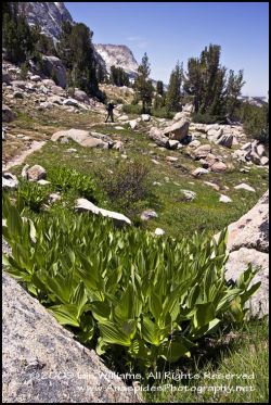 Park bear box. For non Americans reading this, the reason for removing all food stuffs from the vehicle is that black bears patrol the region and with their exceptional ability to smell, will literally break into a vehicle to dine on any food scraps or other food items left in the vehicle. A 300 pound bear doesn’t use the door to enter a vehicle, but usually pounds up and down on the windscreen until is breaks allowing access.
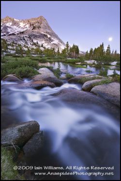
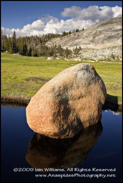
Our first destination was Vogelsang Camp located at an elevation of 10,500 feet. The trail, before rising to a moderate grade, meandered along clear water streams and bright green meadows paralleled by tall majestic pines and underlain with the colour of several species of wildflowers. Imagine the iconic Canadian or American landscape setting and this is what you had – it was picture perfect and telling the truth I would have been happy just sitting by the stream all day watching the birds and other animals pass by.
Certain access trails are also used by mule trains. The mule trains consist of 3 to 6 mules and a few morgan horses and carry supplies to the High Sierra Camps. I was surprised by the volume of dust on the trail which was knocked up by walking boots. The dust comes from the continual erosion of the trail and soon impregnates every nook and cranny. In my opinion this is a good
reason to ban the use of hoofed animals on trails as they are 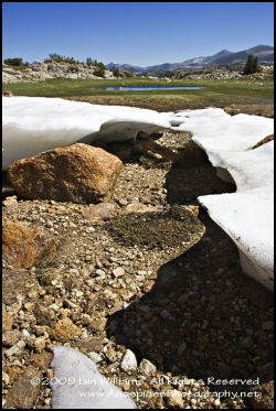 highly damaging to the environment (physical erosion of the track and addition of nutrients from mule droppings), but who am I to argue with the US National Park Authority.
As our group struggled up the incline I was shocked to hear panting and puffing behind me. Upon turning around there was a group of National Park trail workers literally racing up the trail to their stepping off point for trail maintenance. In Australia, trail workers are airlifted into remote regions – it seems in the US they have to walk! More to the point, these hefty workers were carrying all their equipment from radios, packs, shovels, picks and hard hats to water and food! The workers are not confined to super fit males either, as several fit “super” girls were also part of the maintenance group. I think everyone felt a little inadequate as they stormed past us on a mission to hell.
The immediate area around Vogelsang Camp is high alpine, therefore, is glacial and peri-glacial in origin; large granitic domes and glacial moraines are evident in all directions as are several small glacial lakes, braided river streams and small cascades. Near the camp is the trailhead to several hikes of varying length, technical ability and difficulty. We decided to accomplish two hikes during out stay in this area; Hanging Basket Lake and a hike out to the glacial valley.
 HANGING BASKET LAKE
Basket Lake is a hanging glacial lake and to hike to the actual lake takes roughly two hours over undulating terrain. The trail to the base of the end moraine isn’t difficult to traverse, although it does require a bit of rock hopping as you negotiate the granite terrain. I was very pleased to see frogs and numerous tadpoles in some of the braided river sections and small ponds leading to the lake; evidence that the ecosystem is alive and well in this part of the country!
The main climb to the lake begins at the foot of a glacial end moraine (the same moraine that actually caused the lake to develop). The climb is quite precipitous and you must negotiate rocky terrain and a few small ice fields left over from the previous winter. Care must be taken when crossing the ice fields as the ice is partially melted along the under side and can easily shift when weight is placed on the ice. I was pleasantly surprised to observe several marmots cavorting around the rocks and Rebecca and I played leap frog and hide and seek with one particularly bold individual who insisted on playing peek a boo around a large granitic rock.
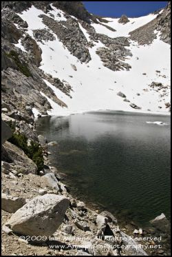
The lake’s relatively small in size, and surrounded on three sides by precipitous cliffs roughly 800 feet in height which form what 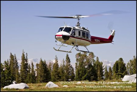 loosely could be called a horseshoe. At the open end of the horseshoe is an end moraine. We reached the lake midmorning and on climbing the last rise of the moraine observed the lake’s water still covered in several places with ice formed from the cool temperatures the evening before. In one area the ice reminded me of small icebergs in Antarctica; this ice soon melted in the mid day temperatures.
MOUNTAIN ACCIDENT
As if to prove the danger of melting ice, upon arrival at Vogelsang Camp we were greeting with the news that a hiker had been injured whilst 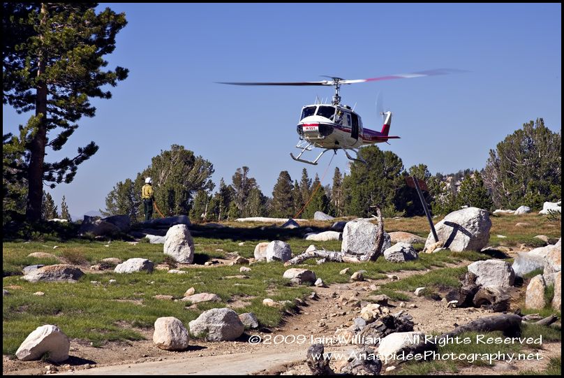 trying to traverse an ice field at the base of Mount Vogelsang. Details were sketchy, but from his partner’s comments (who had returned for help) the person had a fractured wrist, injured shoulder and perhaps a fractured leg. Apparently he had been negotiating an ice field and had “slipped” - or perhaps the ice sheet, partially melted by the warm midday sun had shifted on the smooth granitic rock as he attempted to cross it.
An emergency call had been sent and the National Park Rescue Service had dispatched a 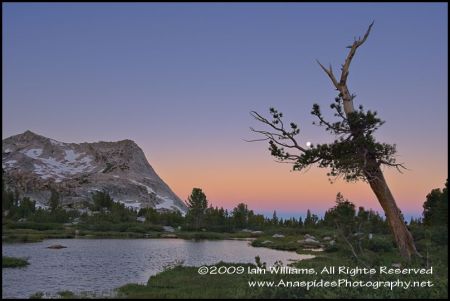 rescue helicopter to the location. It wasn’t long before the tranquil
 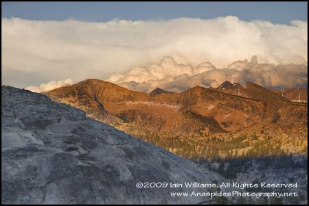 setting of the high alpine fields were echoing to the regular thumping of a Bell Huey helicopter as it circled several times around the location of the injured hiker. It felt like a television re-run was being made of “tour of duty” as the helicopter swung low over pine trees before belly flopping onto the field adjacent our camp. I’m always amazed at how much load space a huey has as it disgorged six rescue personnel and an assortment of rescue and medical equipment.
We soon learnt that a hover 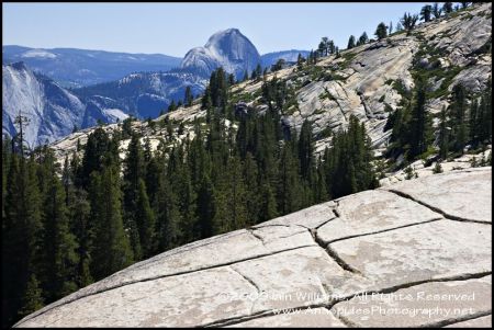 rescue had not been possible due to strong wind conditions over the peaks, and an alterative method of rescue was being sort. A 100 foot line was unraveled and two rescue officers buckled themselves into harnesses and attached themselves to the line. Soon after, the huey was hovering above the men, taking up the slack in the line, before airlifting the two human “spidermen” to the injured hiker. It must have been one awesome ride for the two officers as they dangled beneath the machine at the “apparent” mercy of the strong wind. They reminded me of spiderlings about to be released
 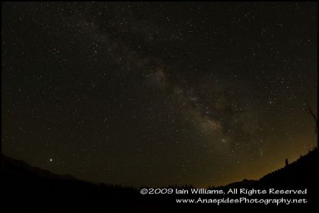 from the mother spider in the wind!
The spidermen were lowered to the injured hiker, disengaged themselves from the line and the huey returned to belly flop once again to the meadow. A short time later the radio crackled and a message was received that the injured hiker had been stabilized by the paramedic, had been strapped to a airborne litter, and egress was required. Once again the aluminium flying monster stirred to life with the now familiar “thump thump thump” of the wide rotors and made its way back to the mountain peak to  collect its human cargo. After landing once again, the injured hiker was given additional medical treatment before being loaded into the huey for final transport to a regional hospital.
Overall, the time lapse from the time that the injury was reported to collection and medical stabilization was around 3-4 hours – not bad considering the remoteness of the region. This time would have been shorter if the hiker had been carrying a personal emergency response beaker such as the popular SPOT Beacon, and had not relied on his walking buddy to seek help.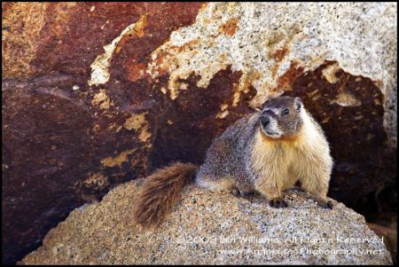 GLACIAL VALLEY HIKE
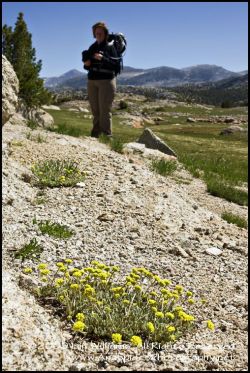
The second hike we did in the area was also very worthwhile and involved following a trail past several small glacial lakes to the edge of a hanging valley. I observed tadpoles and frogs at the margins of the lake and the view from the edge of the glacial valley is very impressive. Furthermore, along the way to the glacial valley are several low granite domes which can be climbed and explored. Growing adjacent to many of the domes, in the eroded granitic grus (grus is crumbled granite that forms by the physical weathering from hot and cold cycling of daily and 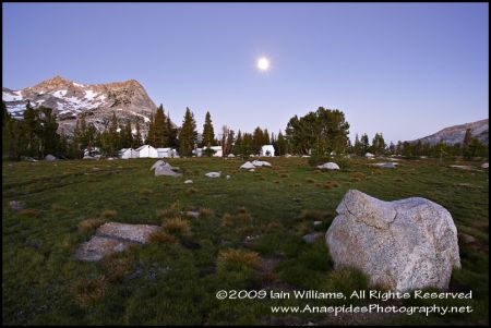 nocturnal temperatures) can be found spectacular alpine wildflowers.
The trail is a very easy grade and it’s best to take your time and savour the sights. You can spend almost the whole day ferreting around the area searching for marmots and ground squirrels and observing the many species of alpine flowers. Our group was lucky to also see a bald eagle and golden eagle riding the thermals searching for unwary ground squirrels!
Vogelsang Camp to Merced Lake
There are two trails to Merced Lake, one trail rises in elevation and encompasses a visit to Vogelsang Peak whilst the less timid but more scenic outer trail bypasses the peak – we choose the later. The trail isn’t that difficult as it’s predominately moving towards lower elevations, however, the trail distance is rather long and the rocky and switchback nature of the trail makes hiking rather slow – if you have bad knees you will definitely feel the strain!
As you descend below the tree line the ecotone alters from high alpine meadows to initially short stunted trees shaped by the prevailing winds, and stunted by the exceptionally cold temperatures, to taller trees with a lush green under story.
At one section of the trail it was evident that the area had been burnt. Closer investigation revealed that lightening had struck a large tree shattering its upper branches and trunk. The large pine had literally exploded into several large fragments. The destruction reminded me of a World War Two movie in which you see trees that have been levelled by aerial bombing and artillery fire.
Each year there are thousands of lightening strikes in Yosemite National Park of which many strikes cause fires. The reason there is so much lightening in the park is due to the uplifting ability of the High Sierras. Weather arriving at the base of the mountains from the Pacific Ocean is forced upward and over the peaks to become unstable and develop into severe weather events. The large amount of bare granite rock acts as a spike to which the lightening is attracted. If the granite domes were not present in Yosemite, much of the lightening would mostly be sheet and intra-cloud lightening.
The Park Service does not combat naturally generated fires, instead using its resources to fight man made fires and create fire breaks. As such, fires and smoke in the Yosemite region can be and is a relatively frequent event.
As you descend further in elevation, the trail winds past several meadows interspersed with winding streams and flanked with flowering spring wildflowers and massive granite domes on each side of the trail. Brown trout can be observed in several of the lakes and in the quieter regions of the streams. This particular area is very beautiful.
Merced Lake is nestled between two glacial valleys and is a lake of quite some distinction and size. The far side of the lake abuts a massive granite cliff and dome which really needs to be seen to actually get a feel for the size. Photography is relatively easy if you can put up with the bugs, but to acquire a decent image, a 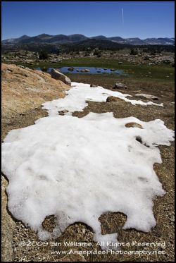 good knowledge and ability to select the appropriate composition is required.
The Merced Lake Camp is located about a mile from the lake, but despite this distance, things that eat you on the fly are still prevalent.
Merced Lake To Sunrise Camp
The next two days were relatively easy walking visiting local sites around Merced Lake. No one in the group was looking forward to the next segment of the trip to Sunrise Camp which would encompass a strenuous steep climb back to altitude. Furthermore, the coolish temperatures experienced at high altitude at Vogelsang Camp had long been replaced with a more humid and warm temperature.
I found the trail to Sunrise Camp interesting, however, the steep inclines and warm conditions tended to work against you. Along one section of the trail I found a number of relatively rare snow Lillys (located in a moist dark area) and several stands of white rhododendrons. I actually smelt the rhododendrons before I saw them. The rhododendrons were a surprise as this plant grows only in acid soil, and granite breaks down to develop into a alkaline soil. I then realized that the region was dotted with pines  and the fallen pine needles alter the alkaline soil to an acid soil allowing the rhododendrons an ideal soil mix to thrive. The white flowers, although smallish due to altitude, were some of the best I have seen.
Rebecca and I sat and photographed the flowers for some 40 minutes and then Rebecca was lucky enough to very briefly observe a Yosemite black bear foraging in the underbrush a little way distant.
The area around Sunrise Camp was impressive; large granite domes and plateaus surrounded by several woodland ridges and meadows.
Several short duration hikes begin at Sunrise Camp and my favourite was a 2 mile hike to a small glacial lake located over the ridge adjacent to the camp. I was surprised when everyone in the group negated on visiting the lake due to the insect numbers at the lake’s shore. I persisted and was rewarded for my efforts with a tranquil lake offering reflections of the surrounding forest.
The evening sky at Sunrise Camp was exceptionally clear and Rebecca, Enrique and I decided to try our luck at photographing the Milky Way.
This was our first opportunity to do any start trails on the trip due to earlier evenings being too cloudy. The biggest hassle we soon discovered was eliminating the tell tail lights of commercial jetliners and US Airforce fighter aircraft, which for some reason or another had decided to fly about that evening.
Sunrise Camp was also the first time during the hike that I wished dearly I had lugged my longer wildlife glass with me. In the meadow adjacent to our camp, Rebecca had discovered a colony of ground squirrels. The colony was quite large and included several adults and around 10 youngsters. Although you could get quite close, it just wasn’t closer enough for me - I needed my long glass. I often rant that the experience comes before the image, and it was at this time that I began to eat my words!
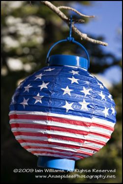 LEFT: This was a 4th of July celebration lantern that I found in a tree along side on the campsites - seems the stars & stripes are everywhere!
Still, it was highly enjoyable lying in the grass and mud and watching the squirrels go about their daily business. It was adorable watching the youngsters play and romp under the watchful eye of a nearby adult. At one stage Rebecca fell asleep on the meadow and I almost saw her being carried away by “flying teeth” and mosquitoes. These flying beasties were exceptionally bad around the squirrel colony and often it was difficult to “shoot” through the swarm!
Sunrise Camp to Tuolumne Meadows (Where We Started)
The last component of the hike was relatively easy as it was a downhill gradient to roughly 7000 feet in elevation, although the trail length of 9 miles grated a little.
The scenery along parts of this trail was spectacular. I can vividly remember turning around a corner on the trail and viewing a glacial tarn surrounded by a lush green meadow of one foot thick sphagnum moss. Reflecting in the tarn’s water were the nearby peaks. As enthralling the spag moss and tarn were, the “flying teeth” and mosquitoes prevalent around the lake soon made their presence known, and even a fresh application of DEET and addition of a head net didn’t stop them from their blood thirsty mission. In fact, with the exception of the squirrel colony at Sunrise Camp this was by far the worst that the bugs had been. I guess it’s not surprising that the insect population increases as you descend to warmer more favorable conditions.
You realized you were getting closer to civilization (well let’s say other people) when you began to meet day hikers outbound from Tuolumne Meadows. Talking with the approaching hikers I discovered that many were making their way to a lake called Cathedral Lake to sunbath and swim. Sure it was warm, but it was amusing to observe buxom girls wearing bikinis tops and shorts who obviously had not read anything about the hordes of large hungry mosquitoes and “flying teeth” awaiting them at the destination! Another hiker, more dressed for hiking than the beach, pounded his way along the trail with an i-pod screaming in his ear! I’m guessing he had not passed nature 101 at school. It seemed that the experienced were meeting the inexperienced. Closer the trail end, Rebecca and I were part of an amusing incident. We had decided, after walking the last 3 miles in warm conditions, to take a short break. Sitting down with our packs beside us, we were surprised to see that nearly every person that passed us on the way up the trail gave us a weird look. What’s odd about two hikers stopping for a rest? We soon understood the reason for the odd looks - the beginning of the trail was only 5 minutes away! Everyone must have thought we were way out of condition resting after only hiking for 5 minutes – no one knew we were on our way OUT and not in.
The trail ended at the Visitor’s Centre and from here we caught the free shuttle to the car park where we had begun our trip nine days earlier.
Was it a good trip? – sure was.
Would I go again? – sure would.
Photographs are not in any particular order.
 Iain Williams
Reader Comments (2)
nice post! i love the photos!
I also know Rebecca Jackrel. She is full of herself and her vanity is a large as her ass. She "implies" she makes all her money from photography but in reality her husband's family support her.