 The drive from Alabama Hills to Death Valley was extremely interesting. The highway runs parallel between two crumple zones that make the Sierra Ranges before slowing gaining altitude to cross the Sierras roughly at 5000 feet. After reaching the alpine desert pass a drop is made into Death Valley.
The most imposing thought on my mind as we descended into Death Valley from the pass is that it is HUGE. The terrain is so expansive that it's very difficult to determine scale. That is until you see a very tiny speck of a car on the valley floor and say "Geez, this place is massive".
Alluvial fans flow from the snow capped Sierra Mountains and prograde into Piedmont fans before transgressing into playa terrain. There's only a few access points to the Death Valley National Park and the road I used passed though a small 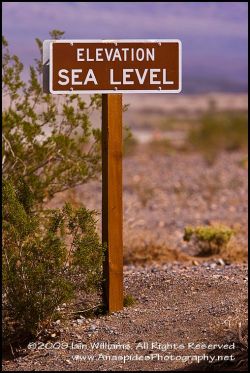 settlement (post office, gas station and RV park) before crossing the playa to climb another crumple zone before entering Death Valley proper.
Half way across the valley floor I heard a huge roar! Expecting an earthquake or some other large geological event I glanced toward the sky to see a US Airforce F18 (or similar) buzzing the car at only a few hundred feet. The aircraft then banked, turned over and made another run! I was to learn that Death Valley is a training and testing ground for the US Airforce based at Edwards Airforce Base. During the next few days the occasional roar could be heard as a test pilot flew his/her machine close to the valley floor banking and arching like a highly maneuverable insect.
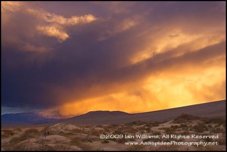
Death Valley is supposed to be - well - very dry. But, on this visit it was raining and much of the park was closed to traffic; before I arrived it had rained heavily and torrential rains had flooded many areas; rock slides and debris covered many of the access tracks and roads. It was unfortunate, but many of the outstanding areas such the "Racetrack" were closed due to heavy rain, flooding and road washouts.
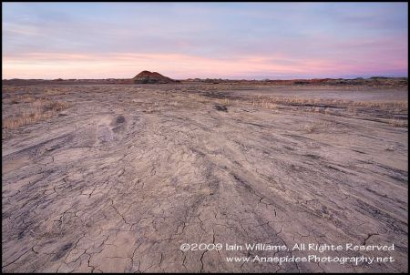
Playa lakes (the area between the mountains which are usually dry) were small shallow lakes and vegetation was surrounded by shallow water. As there was cloud cover, much of the afternoon was spent photographing the snow capped mountains and desert areas inundated with water. At one stage a storm came though and the clouds turned black and ominous 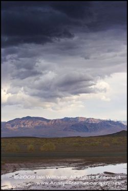 looking, however, the rain fell elsewhere.
Despite the damp conditions, much of the area is covered in salt and low lying vegetation. In some areas exquisite salt formations can be seen such as at the Devil's Golf Course. Of cause the whole region is at or below sea level and has the lowest elevation within the United States.
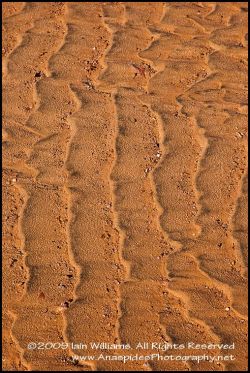
Death Valley has three major dune systems (wind blown sand) and initially when I first saw the dunes I thought they were piles of dirt set aside for road crews to maintain the road. I was shocked when I saw the scale of these dunes - as with everything in this area the dunes were HUGE and expansive. The dune morphology was very fine sand shaped by unidirectional winds to form barcan dune systems.
Initially I thought it would be best to hike to the dunes (only a mile or so from the road), however, on careful observation I noted that many of the dunes were imprinted with marks from the recent rain, and from some careless visitors who had climbed several of the dunes. As it was almost sunset and the light was low I decided to use my 500/4 telephoto in landscape mode rather than hike out and maybe miss the golden light.
I spent two nights in Death Valley (I would have spent more if rain had not closed off several sections of the park). Road crews were busy repairing sections of tracks that had been made impassable, however, I doubted their task when I observed a tractor sweeping dust from the highway!
 Sunsets were spent on the playa photographing the changing vista with salt and salt puddle formations in the foreground while the two sunrises were spent at Zabriskie Point, an area noted for it colourful rock formations and back dropped by the massive snow capped Sierra Range.
Sunrise in Death Valley is cold, however, due to cloud cover the temperatures were not as severe as they could have been. Still, an icy wind seemed to permeate every layer I wore and my hands stung - especially when manipulating a carbon fiber tripod. Zabriskie Point was not disappointing and many images could be created at this location due to the changing colours and formations; leading lines and s curves can be seen everywhere!
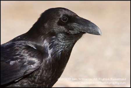
The final morning was spent photography two desert ravens. Ravens are very intelligent and it was interesting to note the behavior between these two birds. At one stage one bird collected some food and keeping the food in its crop hopped toward the other bird. The raven then offered the morsel to its partner. I have never seen this behavior before, despite spending many hours observing ravens.


 An area infrequently visited area, the Bisti Badlands is an undeveloped park with no facilities, information or track guidance. The access track to the Bisti isn't that erroneous, although there are a few ruts which may annoy 2 wheel vehicle owners.
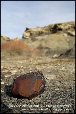 Of course the dinosaurs are now long gone (pity), however, remnants of the forest can still be found in the guise of mounds of petrified wood.
 Iain Williams